


SRS Environmental Report 2004
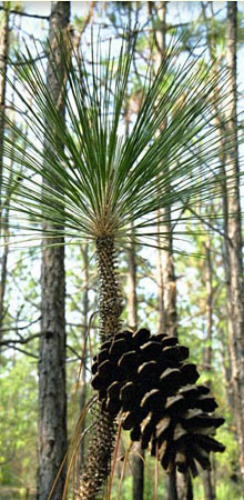
The longleaf pine (pinus palustris) is one of the dominant pine species at SRS. Distributed in the Atlantic and Gulf coastal plains from Virginia to Texas, the trees are common in dry, sandy locations. At maturity, they generally reach 80-120 feet in height and up to two-and-a-half feet in diameter (with a maximum height of 150 feet and diameter of four feet). They produce cones up to 10 inches long. The longleaf is the preferred pine species of the endangered red-cockaded woodpecker, and large areas of SRS are managed for the species because of the woodpecker. The trees are harvested for timber, and their pine straw (from needles reaching 15 inches in length) is used extensively in landscaping projects. The 2004 SRS Environmental Report's interactive CD and associated web page were designed by Don Lechner and the report cover by Eleanor Justice – both of the Westinghouse Savannah River Company's Documentation and Information Services Section – Media Documentation Group. The photograph was taken by Al Mamatey of the company's Environmental Services Section.
Sidebar Data
- Soil & Groundwater Closure (PDF)
- Solid Waste (PDF)
- SREL (PDF)
- High-Level Waste (PDF)
- Site D&D (PDF)
- Forestry (PDF)
- Maps (PDF)
Environmental Report for 2004
- Disclaimer (PDF)
- Title Page (PDF)
- Acknowledgments (PDF)
- Preface (PDF)
- Table of Contents (PDF)
- List of Figures (PDF)
- List of Tables (PDF)
- Sampling Location Information (PDF)
- Chapter 1 – Introduction (PDF)
- Chapter 2 – Environmental Compliance (PDF)
- Chapter 3 – Effluent Monitoring (PDF)
- Chapter 4 – Environmental Surveillance (PDF)
- Chapter 5 – Potential Radiation Doses (PDF)
- Chapter 6 – Groundwater (PDF)
- Chapter 7 – Quality Assurance (PDF)
- Appendix A – Applicable Guidelines, Standards, and Regulations (PDF)
- Appendix B – Radionuclide and Chemical Nomenclature (PDF)
- Appendix C – Errata (PDF)
- Glossary (PDF)
- References (PDF)
- Units of Measure (PDF)
- Fractions and Multiples of Units/Conversion Tables (PDF)
Effluent Monitoring
- National Pollutant Discharge Elimination System Industrial Wastewater Monitoring Data (XLS)
- National Pollutant Discharge Elimination System Land Application Monitoring Data (XLS)
- National Pollutant Discharge Elimination System Stormwater Monitoring Data (XLS)
- Radioactive Atmospheric Releases by Source (XLS)
- Radioactive Atmospheric Releases by Stack-Facility and Comparison of Annual Average Concentrations to DOE Derived Concentration Guides (XLS)
- Radioactive Atmospheric Releases Outfall-Facility and Comparison of Annual Average Radionuclide Concentrations to DOE Derived Concentration Guides (XLS)
- Radioactive Liquid Releases by Source (Including Direct and Seepage Basin Migration Releases) (XLS)
- Radioactivity in Air Effluent Samples (XLS)
- Radioactivity in Liquid Effluent Samples (XLS)
- Toxic Air Pollutant Emissions (2003) (XLS)
Environmental Surveillance
- Fish Surveillance – Mercury (XLS)
- Migration of Radioactivity from Seepage Basins and SWDF (XLS)
- Radioactivity in Air (XLS)
- Radioactivity in Aquatic Food Products – Freshwater Fish (XLS)
- Radioactivity in Aquatic Food Products – Saltwater Fish (XLS)
- Radioactivity in Aquatic Food Products – Shellfish (XLS)
- Radioactivity in Drinking Water (XLS)
- Radioactivity in E-Area Stormwater Basins (XLS)
- Radioactivity in Grassy Vegetation (XLS)
- Radioactivity in Rain Ion Columns (XLS)
- Radioactivity in River and Stream Sediment (XLS)
- Radioactivity in Savannah River Site Stream Water (XLS)
- Radioactivity in Savannah River Water (XLS)
- Radioactivity in Soil (XLS)
- Radioactivity in Terrestrial Food Products – Greens, Fruit, and Beef (XLS)
- Radioactivity in Terrestrial Food Products – Milk (XLS)
- Savannah River Swamp (Creek Plantation) Survey – Soil and Vegetation Results (XLS)
- Sediment Surveillance – Inorganic Contaminants, Pesticides, and Herbicides (XLS)
- Summary of Savannah River Site Tritium Transport, 1960-2004 (XLS)
- Surface Water Surveillance – Inorganic Contaminants, Pesticides, and Herbicides (XLS)
- Thermoluminescent Dosimeter (TLD) Results – All Monitoring Networks (XLS)
- Tritium in Rainwater (XLS)
- Tritium Transport in SRS Streams and the Savannah River (XLS)
Air Dose Data Tables
- Airborne Releases by Source and Stack Height for NESHAP (XLS)
- Atmospheric Releases, 2000-2004 (XLS)
- CAP88 MEI Dose Compared to MAXDOSE-SR (XLS)
- CAP88 Population Dose Compared to POPDOSE-SR (XLS)
- Comparison of 2000-2004 Offsite Doses (XLS)
- Comparison of Measured vs. Calculated Tritium-in-Air Concentrations (XLS)
- Diffuse Releases and MEI Doses for NESHAP (XLS)
- MAXDOSE-SR MEI Dose Using Cow Milk (XLS)
- MAXDOSE-SR MEI Dose Using Goat Milk (XLS)
- Meteorological Data (XLS)
- Population Dose from Airborne Releases POPDOSE-SR (XLS)
- Radioactive Atmospheric Releases by Source (XLS)
- Release Locations for Maximally Exposed Individual (XLS)
- Sector-Specific Adult MEI Dose (XLS)
- Site-Specific Parameters Used for Airborne Pathway Doses (XLS)
- Site-Specific Parameters Used with CAP88 for NESHAP (XLS)
- Total Airborne Releases and MEI Doses for NESHAP (XLS)
Liquid Dose Data Tables
- Collective Dose – Liquid (XLS)
- Deer and Hog Hunter Doses (XLS)
- Effective River Flow (XLS)
- MEI Dose – Liquid (XLS)
- MEI Water Dose – Beaufort-Jasper (XLS)
- MEI Water Dose – Port Wentworth (XLS)
- Paramenters Used for Liquid Pathway Dose Calculations (XLS)
- Potential Dose from Irrigation (XLS)
- Radioactive Liquid Releases, 2000-2004 (XLS)
- Radioactive Liquid Releases by Source (Including Direct and Seepage Basin Migration Releases) (XLS)
- Savannah River Mile 118.8 Flow Rate, 1954-2004 (XLS)
- Screening of Biota Doses Using BCGs (XLS)
Quality Assurance
- Blind Sample Results for pH Field Measurements (PDF)
- Blind Sample Results for Tritium (XLS)
- NPDES Blind Sample Results (XLS)
- NPDES Duplicate Sample Results (XLS)
- QAP Interlaboratory Comparison of Analytical Results (PDF)
- Quality Assurance-Quality Control Standards (XLS)
- SRS Stream and Savannah River Water Quality Duplicate Sample Results (XLS)